This is the winter Southwest done right: West Texas's Big Bend country paired with the high-desert byways of Northern New Mexico. You start in the far corner of Texas — Big Bend National Park, the canyons of the Rio Grande, and the FM 170 "River Road" (El Camino del Rio) — then drive north for New Mexico's Turquoise Trail and High Road to Taos. It's the best cool-season driving in the country under some of the darkest skies in North America. One thing up front: the two regions are roughly a long day's drive apart across the Chihuahuan Desert, so treat this as a linked two-part trip, not one continuous road. Here's the honest route — the pacing, the stops worth the detour, and the remote-desert logistics you actually need.
Canyons of the Rio Grande to New Mexico's art towns — under the darkest skies in the Lower 48.
What this Big Bend + New Mexico trip actually is
This isn't one named highway — it's two of the great desert-driving regions of the Southwest strung into a single winter road trip. The southern half is Big Bend country in far West Texas: the national park of Rio Grande canyon walls and the green Chisos Mountains, plus the FM 170 "River Road" between Lajitas and Presidio through Big Bend Ranch State Park. The northern half is Northern New Mexico: Santa Fe, the Turquoise Trail's mining towns, and the High Road to Taos through adobe villages.
The honest catch is the middle. Big Bend sits in a remote corner of the continental US, and Santa Fe is roughly 500 miles north across the Chihuahuan Desert — a full day behind the wheel. Think of it as a two-part trip that shares a season and a mood, not a road. What ties them together is winter: while the rest of the country ices over, West Texas and the New Mexico high desert are at their best — cool days, crisp nights, and, in Big Bend, a sky so dark it stops you in the parking lot.
Big Bend & New Mexico map
The two-part route at a glance — Big Bend country in West Texas, then north to New Mexico.
When to go: this is a winter trip
Get the season right and everything follows. The window is November through March. Big Bend's summer is genuinely dangerous — desert-floor highs climb past 100°F and the exposed hikes turn hostile — so the park's peak season is the opposite of most, filling over the winter holidays and into spring. New Mexico's high desert is cold but clear, with the payoff of snow-dusted adobe villages.
The sweet spot is late November to early March, when Big Bend's daytime temperatures are hiking-perfect and crowds thin out midweek. Expect a real day-to-night swing: afternoons can be shirt-sleeve warm while nights drop below freezing, especially in the Chisos Basin and the New Mexico high country. Pack layers and check park and road conditions before every leg, because high-desert weather shifts fast. If summer is your only window, do New Mexico's higher north and skip the Big Bend desert floor.
Direction, pacing, and remote-desert logistics
Drive south to north
Start with Big Bend and finish in New Mexico. You get the hard, remote driving done while you're fresh, the landscape opens from river canyons to high-desert mesas, and you end somewhere with restaurants and an easy airport. Reverse it if your flights make more sense — but south-to-north is the natural build.
How long it honestly takes
Give each region about four days and the connecting drive a full day, so 7 to 10 days total. Big Bend alone works in four or five days, New Mexico's byways in three or four. But if you want both, don't rush the middle — the drive north eats an entire day. The daily drive-time caps in our planning guide matter here: the map looks empty and fast, but these are long, tiring desert miles.
Fuel, water, and cell coverage
This is the part people underestimate. Fuel gaps run 60 to 100 miles, cell service is patchy to nonexistent across the park and the River Road, and there's no quick help if something goes wrong. Treat it like backcountry: top off at every station, carry more water than you think you need, download offline maps, and tell someone your plan. FM 170 is especially steep — the "Big Hill" is a punishing grade with tight, blind curves — so drive it rested and in daylight.
The Big Bend + New Mexico itinerary, leg by leg
Because this links two regions, here it is in seven legs, south to north — Big Bend first, then the long haul, then the New Mexico byways. Mileages and times are planning estimates for the scenic routing, not the interstate, so build in extra.
El Paso → Marfa, Fort Davis & the dark skies
Fly into El Paso or Midland-Odessa and drive south into wide-open West Texas toward the Marfa-Alpine-Fort Davis triangle. Give Marfa a day for its art galleries, the roadside Prada Marfa sculpture, and the Marfa Lights platform, then loop up to the McDonald Observatory near Fort Davis, whose public star parties are your first taste of the region's world-class dark skies.
Alpine → Terlingua & Study Butte
Drive to the park's western gateway and settle at Terlingua, the old quicksilver-mining ghost town that's become Big Bend's offbeat basecamp — a townsite of ruins, a cemetery, and a famous front porch. The wider Study Butte area holds the outfitters, river launches, and most western-side lodging.
The River Road: FM 170, Lajitas → Presidio
The drive the trip is named for. FM 170, El Camino del Rio, runs west from Lajitas through Big Bend Ranch State Park, tracing the Rio Grande with Mexico on the far bank — one of the country's most scenic drives. It climbs the notorious "Big Hill" overlook and passes Closed Canyon's slot and the Contrabando ruins before Presidio. Drive it out and back.
Big Bend National Park
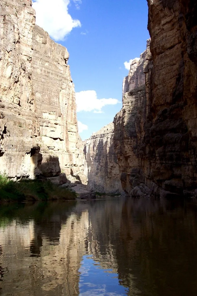
The centerpiece, and it earns multiple days. Hike into Santa Elena Canyon, where the Rio Grande splits a 1,500-foot wall off the Ross Maxwell Scenic Drive. Base a night in the Chisos Basin for the Window view. Soak in the riverside hot springs and — with your passport — cross to Boquillas del Carmen, Mexico. After dark, look up: an International Dark Sky Park with some of the blackest skies in the Lower 48.
Big Bend → Santa Fe (the long haul north)
The connective tissue, and there's no way to make it short: a full day north out of the Big Bend desert, across the Chihuahuan Desert and up the Rio Grande valley toward Santa Fe. Fuel and services are sparse, so plan your fill-ups and don't start on a low tank or late. If one push feels brutal, break it with a night partway along the interstate corridor.
Santa Fe & the Turquoise Trail
Reset in Santa Fe — adobe old town, plaza, galleries, and green chile on everything — then drive the Turquoise Trail (NM-14) south toward Albuquerque through old mining country. The star is Madrid, a onetime coal town reborn as a strip of artist studios, with old Cerrillos nearby. It's an easy, low-mileage day that drops you into Route 66 country.
The High Road to Taos
Finish on the High Road to Taos, winding through adobe villages. Stop at Chimayó for El Santuario de Chimayó, famous for its "holy dirt," climb through Truchas, and see the old church at Las Trampas. In Taos, tour Taos Pueblo — a continuously inhabited World Heritage adobe community — then drive to the Rio Grande Gorge Bridge for one last canyon. A fitting close: the same river you left in Big Bend, a different desert.
Only have time for one region?
This trip splits cleanly. Do Big Bend alone for canyons, the River Road, and dark skies — four or five days out of El Paso. Or fly into Albuquerque for just the New Mexico byways. Build either half — your dates, your pace — in the planner.
Plan your Big Bend trip →Best stops on the Big Bend + New Mexico route
If you can't drive the whole thing, these are the stops worth building a trip around, south to north.
- Marfa & the McDonald Observatory, TX — a high-desert art town (Prada Marfa, the Marfa Lights platform) and star parties under world-class dark skies.
- Terlingua ghost town, TX — a former quicksilver-mining townsite turned offbeat basecamp, the park's western gateway.
- FM 170 "River Road," TX — El Camino del Rio between Lajitas and Presidio, the Big Hill overlook.
- Santa Elena Canyon, Big Bend NP, TX — the river between 1,500-foot walls, the signature Big Bend view.
- Chisos Basin, Big Bend NP, TX — the park's green mountain heart, the Window view, and the best hiking base.
- Hot springs & Boquillas crossing, TX — a riverside soak and a passport crossing to Boquillas del Carmen, Mexico.
- Big Bend night skies, TX — an International Dark Sky Park among the darkest in the Lower 48; bring a red flashlight.
- Santa Fe, NM — adobe old town, galleries, and green chile; the hub for the New Mexico half.
- Madrid & the Turquoise Trail, NM — a reborn coal town of artist studios on the NM-14 back road.
- El Santuario de Chimayó & Taos Pueblo, NM — the High Road's pilgrimage church and the World Heritage adobe pueblo that ends the trip.
Big Bend National Park vs Big Bend Ranch State Park
People mix these up constantly. They're neighbors on the Rio Grande, but — crucially — the famous FM 170 River Road runs through the state park, not the national park. Want the canyons and dark skies? The national park. Want the scenic drive and solitude? The state park. Most trips do both.
| Big Bend National Park | Big Bend Ranch State Park | |
|---|---|---|
| Size & crowds | ~800,000 acres; busiest in winter/spring, still quiet by park standards | ~300,000 acres; Texas's largest state park, far fewer people |
| Services | Visitor centers, an in-park lodge, developed campgrounds, some fuel | Minimal — a couple of visitor centers, primitive camping, no services |
| The FM 170 scenic drive | Not here — the park has its own roads (Ross Maxwell Scenic Drive) | Yes — FM 170 / El Camino del Rio runs through it, Lajitas to Presidio |
| Permits & backcountry | Entrance fee; backcountry permit for wilderness camping | Day-use/camping permits; rugged 4WD roads and hike-in sites |
| Best for | First-timers, iconic canyons, wildlife, the Chisos, dark skies | The River Road, overlooks, solitude, real remoteness |
Short version: base out of the national park for the canyons and stargazing, and set aside a half-day for FM 170 through the state park. For another Southwest canyon option, our Utah Mighty 5 guide covers the busier alternative to the north.
Costs and practical tips
A rough per-person budget for the full 7–10 day trip, based on two people sharing a car and mid-range motels. These are planning estimates, not live prices — check current fuel and lodging before you book.
| Item | Estimate | Notes |
|---|---|---|
| Fuel | $160–$230 (whole car) | ~1,100 mi at ~25 MPG ≈ 44 gallons; remote fill-ups run pricier. |
| Lodging | $110–$200 / night | In-park and gateway rooms are limited and book out in winter; Santa Fe and Taos run higher. |
| Food | $40–$65 / person / day | Simple in Big Bend country; worth a splurge in Santa Fe and Taos. |
| Parks & permits | $60–$120 / person total | Park entry, state day-use, tours, star parties. |
| 7–10 day total | ~$1,300–$2,200 / person | Two sharing a car; less camping, more with a rental. |
Practical tips
- Treat fuel and water as safety gear. Fill up at every station, carry extra water, and download offline maps — cell service is unreliable across the park and the River Road.
- Book lodging early. The in-park lodge, Terlingua-area rooms, and gateway motels are limited, and winter is peak season — reserve well ahead.
- Check conditions before every leg. Confirm park and road status and respect FM 170's steep "Big Hill" grade; high-desert weather turns fast.
- Pack for a big day-night swing. Afternoons can be warm while nights drop below freezing — bring real layers and a red flashlight for the dark-sky nights.
Big Bend road trip FAQ
How many days do you need for a Big Bend road trip?
Give Big Bend four or five days for the national park, the Chisos Basin, and the FM 170 River Road. Linking it with Northern New Mexico, plan 7 to 10 days — about four per region plus a full day for the drive north.
When is the best time to visit Big Bend?
Winter — roughly November through March. Big Bend's summer is dangerously hot, with desert-floor temperatures well over 100°F, so the park's peak season is the cool months. Expect warm afternoons and near- or below-freezing nights, especially in the Chisos Basin, and pack layers.
What is the River Road (FM 170) in Big Bend?
FM 170, El Camino del Rio, is a paved scenic highway along the Rio Grande between Lajitas and Presidio through Big Bend Ranch State Park — not the national park. It's known for the steep "Big Hill" overlook, the Closed Canyon slot hike, and the Contrabando ruins.
Big Bend National Park vs Big Bend Ranch State Park — what's the difference?
The national park is the larger, federally run park with the marquee canyons, the Chisos Mountains, an in-park lodge, and dark-sky stargazing. Big Bend Ranch State Park is the smaller, far more remote state park next door, with minimal services — and it's the one FM 170 runs through. Most trips visit both.
How far is Big Bend from Santa Fe, New Mexico?
Roughly 500 miles, about a full day of driving north across the Chihuahuan Desert and up the Rio Grande valley. It's the connecting leg of this two-part trip, with long gaps between fuel and services, so plan an early start or split it with an overnight partway.
Is Big Bend really that good for stargazing?
Yes. Big Bend National Park is a certified International Dark Sky Park with some of the darkest measured skies in the Lower 48, thanks to its remoteness. Add the McDonald Observatory's star parties near Fort Davis, and dark skies are one of the best reasons to make this a winter trip.
Turning this into your Big Bend trip
This route rewards a simple plan: pick a winter window, decide whether you're doing Big Bend alone or linking it with New Mexico, and lock the scarce lodging first, because it drives the rest. Let the desert legs flex around your park days, keep the long haul north as its own travel day, and finish among the adobe villages of the High Road. Get the season and fuel plan right, and the rest takes care of itself.
Plan your own Big Bend trip
Turn this itinerary into a personalized plan — your dates, your pace, your car — with a live map, daily driving times, weather, fuel estimates, and where-to-stay links.
Open the planner →