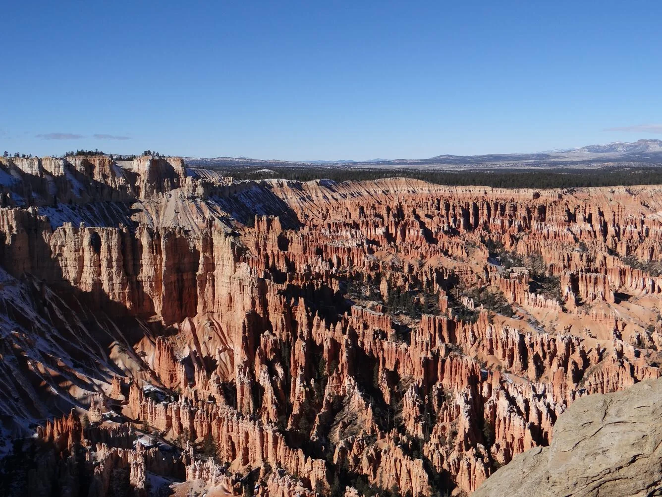
Utah Scenic Byway 12 is only about 124 miles long, but it packs in more scenery per mile than almost any road in America. Officially "A Journey Through Time Scenic Byway" and one of a handful of designated All-American Roads, it runs from near Bryce Canyon east to Torrey, at the doorstep of Capitol Reef, threading straight through Grand Staircase–Escalante National Monument along the way. It's also the smart move for 2026: a tight 3–4 day route that links two of Utah's Mighty 5 while sidestepping the crush at Zion and Arches. Here's the full drive, west to east — the honest pacing, the stops worth stopping for, and how it stacks up against the crowded parks.
124 miles of red rock, slot canyons, and alpine forest — Bryce Canyon to Capitol Reef.
What Scenic Byway 12 actually is
Scenic Byway 12 is Utah State Route 12 — a two-lane highway that runs roughly 124 miles across the high plateau country of south-central Utah, from its junction with US-89 near Panguitch, on the western side, east to the small town of Torrey. It carries two big designations: a National Scenic Byway nicknamed "A Journey Through Time," and the rarer All-American Road status, reserved for roads that are a destination in their own right. On Highway 12, that's not marketing. The road climbs from ponderosa forest into fire-orange hoodoos, drops across slickrock and slot-canyon country, rides a knife-edge ridge with the land falling away on both sides, then tops out in aspen forest near 9,600 feet before dropping to the desert again.
What makes it genuinely useful is what it connects. Highway 12 threads between Bryce Canyon and Capitol Reef — two of Utah's five national parks — and runs straight through Grand Staircase–Escalante National Monument in between. So a single short drive strings together two Mighty 5 parks, a giant national monument, and a couple of excellent state parks. If you want the Utah red-rock experience without committing to the whole Mighty 5 loop, this is the concentrated version.
Utah Highway 12 map
The byway at a glance — Bryce Canyon east to Capitol Reef, through Grand Staircase–Escalante.
When to go
Highway 12 spans a huge range of elevation — from desert canyons around Escalante up over Boulder Mountain near 9,600 feet — so no single month is perfect, but the sweet spots are clear: spring and fall. April–May and September–October give you warm-but-not-brutal days down low, and the high country is open and clear.
Summer works, but the low-elevation stretches around Escalante and Capitol Reef get hot, and afternoon thunderstorms bring flash-flood risk to the slot canyons and washes — check the forecast before any canyon hike. Boulder Mountain is the exception in the heat: at nearly 9,600 feet it stays cool even in July, and its aspens turn gold in late September. Winter brings real snow to the high stretches — Boulder Mountain can hold snow into spring — and while the road is usually plowed, the Hogback and the mountain climb are no place to be in a storm. If you're driving the shoulder seasons, check road and pass conditions before you commit to a day.
Direction, pacing, and logistics
Drive west to east
Go Bryce Canyon to Capitol Reef. The scenery builds the right way — you start in the tidy, famous amphitheater of Bryce, work through the wilder and emptier monument country in the middle, cross the Hogback and Boulder Mountain as the drama peaks, and finish at Capitol Reef, the quietest of the Mighty 5. It also sets you up to end near Torrey, an easy launch point for the rest of southern Utah.
How long it honestly takes
You could drive all 124 miles in about three hours. Don't — this is a destination-dense road where stopping is the point. Plan on 3 to 4 days to do it justice, or a leisurely 5–6 if you want to hike Calf Creek and give each park a full day. The itinerary below breaks it into six unhurried moves; combine the Escalante days and the Boulder–Torrey legs to compress it into a long weekend. The daily drive-time caps in our planning guide matter less here than stop time — the driving is short, but the trails and viewpoints eat the hours.
Services are sparse — plan fuel and rooms
This is remote country. Reliable fuel is limited to Escalante, Boulder, and Torrey, with long, empty stretches between — never start the Hogback or Boulder Mountain on a low tank. Cell coverage is thin to nonexistent across the monument, so download offline maps. Lodging is limited too: Torrey, Boulder, and the Bryce area are small towns with few beds that book out in spring and fall, so reserve ahead rather than counting on a room at dusk.
The Highway 12 itinerary, day by day
Here's the byway broken into six moves, west to east — a savorable pace you can tighten into 3–4 days by pairing the Escalante and Boulder legs. Mileages and times are planning estimates for the scenic routing and the park spurs, not the fast way through, so build in stop time.
US-89 junction → Red Canyon → Bryce Canyon
Highway 12 begins unassumingly at its junction with US-89 south of Panguitch, and within minutes you're in Red Canyon, part of Dixie National Forest, where the road tunnels through fire-orange rock and arches lean over the asphalt — a free, uncrowded preview of what's coming. Turn south on UT-63 to Bryce Canyon National Park, where the Paunsaugunt Plateau drops away into an amphitheater of hoodoos. Walk the rim between Sunrise and Sunset Points, or drop onto the Navajo Loop and Queen's Garden trails to stand among the spires themselves.
Bryce Canyon → Kodachrome Basin → Escalante
East of Bryce the byway opens onto high, rolling country. Detour south from Cannonville to Kodachrome Basin State Park — named by a National Geographic team for its color — where dozens of stone chimneys, called sand pipes, rise straight from the desert floor. Back on 12, roll into the town of Escalante, your base for Grand Staircase–Escalante National Monument. Stretch your legs before dinner at Escalante Petrified Forest State Park, where a short climb reaches fields of colorful petrified wood above a reservoir.
Escalante & Grand Staircase–Escalante
Base out of Escalante and give the monument a day. The signature hike is Lower Calf Creek Falls, a roughly 6-mile round trip up a sandy canyon to a waterfall over 120 feet high dropping into a green pool — flat but deep-sand underfoot, so it's more work than the mileage suggests; carry plenty of water. For something quicker, the hoodoos and natural arches of Devils Garden, just off Hole-in-the-Rock Road, are an easy, otherworldly stop. This is slot-canyon country, so read the sky before you commit.
Escalante → the Hogback → Boulder
This is the byway's showpiece — and its white-knuckle stretch. Between Escalante and Boulder the road climbs onto "the Hogback," a narrow ridge with the land falling away on both sides, few guardrails, and next to no shoulder; the views are staggering and the driving demands your full attention. In Boulder — one of the last towns in the country to get its mail by mule — stop at Anasazi State Park Museum, built beside an excavated ancestral Puebloan village. Boulder is also where the unpaved Burr Trail strikes east into Capitol Reef's remote backcountry.
Boulder → Boulder Mountain → Torrey
The final act climbs over Boulder Mountain through Dixie National Forest, topping out near 9,600 feet in aspen and pine — a cool, green counterpoint to the slickrock below, with pullouts framing the Waterpocket Fold and the Henry Mountains off to the east. Because it's high, this leg stays cool in summer and can hold snow into spring, so it's the one stretch to check before shoulder-season travel. Drop off the mountain into Torrey, a small, walkable gateway town, and set up for Capitol Reef.
Torrey → Capitol Reef National Park
Highway 12 technically ends at Torrey; from here UT-24 carries you the last few miles into Capitol Reef National Park, the least-crowded of Utah's Mighty 5. The park protects the Waterpocket Fold, a nearly 100-mile wrinkle in the earth's crust, and the green oasis of Fruita, where you can walk historic pioneer orchards and, in season, pick fruit. Drive the paved Scenic Drive past the Capitol Dome into the canyons, and don't miss the petroglyph panels along UT-24. It's the quiet payoff for skipping the lines elsewhere.
Only have a long weekend?
Highway 12 compresses well. Combine the two Escalante days and the Boulder–Torrey legs and you have a tight three-day run: Bryce on day one, Escalante and the Hogback on day two, Boulder Mountain and Capitol Reef on day three. Build your version — your dates, your pace, your stops — in the planner.
Plan your Highway 12 trip →13 best stops on Scenic Byway 12
If you can't drive the whole thing, these are the stops worth building a trip around, west to east.
- Red Canyon (Dixie NF) — fire-orange rock and arches leaning over the road, with tunnels blasted through the stone; a free, uncrowded warm-up right at the west end.
- Bryce Canyon National Park — the famous amphitheater of hoodoos; walk the rim or drop into the Navajo Loop and Queen's Garden to stand among the spires.
- Kodachrome Basin State Park — dozens of stone chimneys rising from the desert floor, a short detour south from Cannonville and a fraction as busy as the parks.
- Grand Staircase–Escalante National Monument — vast canyon, plateau, and slot-canyon country that the byway runs straight through.
- Escalante Petrified Forest State Park — colorful petrified wood on a short hillside loop above a reservoir, by the town of Escalante.
- Lower Calf Creek Falls — a roughly 6-mile round-trip hike up a sandy canyon to a 120-foot waterfall and a green pool; the signature trail of the monument.
- Devils Garden — an easy, quick stop of hoodoos and small natural arches just off Hole-in-the-Rock Road.
- The Hogback — the narrow ridge between Escalante and Boulder with drop-offs on both sides; the most dramatic driving stretch on the route.
- Boulder & Anasazi State Park Museum — a tiny, remote town built on an ancestral Puebloan village site, and the trailhead for the Burr Trail.
- The Burr Trail — an unpaved backcountry road east out of Boulder into Capitol Reef's remote canyon country, for the well-prepared.
- Boulder Mountain overlooks (Dixie NF) — aspen forest near 9,600 feet with sweeping views of the Waterpocket Fold and the Henry Mountains.
- Torrey — the walkable gateway town where Highway 12 ends and Capitol Reef begins.
- Capitol Reef National Park — the Waterpocket Fold, the Fruita orchards, and the Scenic Drive; the quietest of Utah's Mighty 5 and the payoff at the east end.
Highway 12 & Capitol Reef vs the Zion and Arches crowds
Zion and Arches are spectacular and everyone knows it — which is the problem. Both now run crowd-control systems in peak season and their lots fill early. Highway 12 delivers the same Utah red rock through Bryce and Capitol Reef, plus a giant monument in between, with a fraction of the people and no reservation to win. If your goal is the scenery and not one specific postcard, this is the calmer play.
| Highway 12 & Capitol Reef | Zion & Arches | |
|---|---|---|
| Crowds | Light to moderate, even in season | Heavy spring through fall |
| Reservations | No timed-entry system on the byway or at Capitol Reef entry | Zion shuttle mandatory in season; Arches uses timed-entry reservations in peak months |
| Scenery | Hoodoos, slot canyons, the Waterpocket Fold, alpine forest | Iconic arches and sheer canyon walls |
| Services | Sparse — fuel and rooms only in Escalante, Boulder, Torrey | Abundant near gateway towns |
| Best for | Red rock without the crush; a tight 3–4 day loop | Bucket-list icons if you don't mind lines |
Short version: drive Zion and Arches for the famous set-pieces if you'll plan around timed entry and crowds; drive Highway 12 for the same red rock, more variety, and room to breathe. Bryce and Capitol Reef are two of the five, so you're not trading away the marquee parks — just taking the quiet door in.
Costs and practical tips
A rough per-person budget for a 3–4 day drive, based on two people sharing a car and mid-range motels. These are planning estimates, not live prices — check current fuel, park fees, and lodging before you book.
| Item | Estimate | Notes |
|---|---|---|
| Fuel | $60–$110 (whole car) | The byway is short, but park scenic drives and getting to the trailheads add up; top up in Escalante, Boulder, or Torrey. |
| Lodging | $110–$220 / night | Small-town rooms in Bryce area, Escalante, Boulder, and Torrey; book ahead in spring and fall. |
| Food | $40–$65 / person / day | Limited options between towns; a few standout spots in Boulder and Torrey are worth a splurge. |
| Parks & attractions | $60–$120 / person total | Bryce and Capitol Reef entry (an annual pass pays off across the Mighty 5), plus state-park fees. |
| 3–4 day total | ~$650–$1,100 / person | Two sharing a car; less if you camp, more with a one-way rental fee. |
Practical tips
- Fuel up in the towns. Reliable gas is only in Escalante, Boulder, and Torrey, with long empty stretches between — never start the Hogback or Boulder Mountain on a low tank.
- Respect the Hogback and Boulder Mountain. The Hogback is genuinely narrow with drop-offs and no shoulder; drive both stretches in daylight and good weather, and wait out storms.
- Check the flash-flood forecast. Slot canyons and washes around Escalante and the monument fill fast in a storm; watch the sky and skip the canyons on stormy afternoons.
- Book rooms early in shoulder season. Torrey, Boulder, and the Bryce area are small towns with few beds that sell out on spring and fall weekends.
Scenic Byway 12 FAQ
How many days do you need to drive Utah Scenic Byway 12?
Plan for 3 to 4 days to drive the roughly 124-mile byway comfortably, with time for Bryce Canyon, Grand Staircase–Escalante, and Capitol Reef. You can push the drive itself into a single long day, but that wastes the point — a savorable pace with the Calf Creek hike and a full day at Capitol Reef runs closer to 5 or 6.
Is Highway 12 a scary or dangerous drive?
Most of it is easy paved two-lane. The exception is "the Hogback," a narrow ridge between Escalante and Boulder with drop-offs on both sides and little shoulder or guardrail. It's paved and manageable at a calm speed in good weather, but it unnerves drivers with a fear of heights. Drive it in daylight, slow down, and avoid it in snow, rain, or after dark.
Which national parks does Scenic Byway 12 connect?
Two of Utah's Mighty 5: Bryce Canyon at the west end and Capitol Reef at the east end, near Torrey. In between it runs straight through Grand Staircase–Escalante National Monument and passes several state parks, making it one of the most efficient ways to string together southern Utah's red rock.
Is Capitol Reef a good alternative to Zion or Arches?
Yes. Capitol Reef is the least-crowded of Utah's five national parks and, unlike Zion (mandatory seasonal shuttle) and Arches (timed-entry reservations in peak months), it doesn't require a reservation to enter. You get the Waterpocket Fold, the Fruita orchards, and a quiet scenic drive with a fraction of the crowds. Pairing it with Bryce via Highway 12 gives you two national parks without the peak-season crush.
When is the best time to drive Scenic Byway 12?
Spring and fall. April–May and September–October give warm days at low elevation and open, clear roads up high. Summer is hot around Escalante and Capitol Reef and brings afternoon flash-flood risk to the slot canyons, though Boulder Mountain stays cool. Winter brings snow to the high stretches — Boulder Mountain can hold it into spring — so check road conditions before shoulder-season travel.
Do you need reservations or a timed-entry permit for Highway 12?
No. There's no timed-entry system on Scenic Byway 12, and neither Capitol Reef nor Bryce Canyon requires a reservation to enter. You'll still want to book lodging and any guided tours or backcountry permits ahead, and confirm current park rules before you go — but it's one of the few red-rock routes in Utah you can drive without winning a reservation window.
Turning this into your Highway 12 trip
Highway 12 rewards a simple plan: pick a spring or fall window, decide between the relaxed 5–6 day version and a tight long weekend, then lock rooms in Torrey, Boulder, or the Bryce area early because the towns are small. Build the days around the two parks and the Calf Creek hike, watch the weather on the Hogback and Boulder Mountain, and let the monument stretch flex around them. Then point the car east and let the byway do the rest.
Plan your own Highway 12 trip
Turn this itinerary into a personalized plan — your dates, your pace, your car — with a live map, daily driving times, weather, fuel estimates, and where-to-stay links.
Open the planner →